HEBDEN BRIDGE WALKERS ACTION
901 BUS WALKS 1
Cragg Vale to Ripponden along the
Calderdale Way
This walk follows the Calderdale way (there are Calderdale way waymarks along the route) and takes you through upland pastures and moorland
Length and time
It’s about 8 km (approx 5 miles) and should take you about 3 hours (plus stops).
Gradients – how strenuous
The walk includes two uphill sections each followed by a downhill.
Terrain – how uneven
Some of the walk is on farm tracks and lanes, some is on footpaths.
Obstacles – stiles, steps etc.
There are several stiles and gates.
Facilities
White House pub does food, but check opening times
Points of interest
Spectacular views of Lancashire and Greater Manchester, upland moors, occasional sightings of skylarks and curlews
DIRECTIONS (Click here for Printable Version)
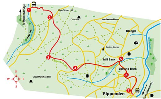
Ask the driver to put you off at the 901 bus stop on Cragg Road opposite the
Hinchliffe Arms turning.
1. Walk 50 metres back down the road to the start of a terrace of houses and take the track, going off to the right behind the terrace. At the ornate gates take the narrow path going up to the right of the laurel hedge. After a short climb, turn left after the laurel hedge onto a stone paved path heading uphill. At the end of the wall cross the stream, turn right uphill towards a farmhouse. At the farmhouse, go over the stile, and turn sharp right uphill on to a track.
2. This track zigzags uphill for 500 metres, ending up at Bent Close Farm on the right. At the junction just after the farm, turn right along the road for 200 metres. At the cross roads, go straight over onto a tarmac bridleway. Continue past Catherine House Farm (with the chimney) and keep on the track, with the wall on your right. The track continues through a field, still with the stone wall on your right.
3 At the top of the hill, turn right on to a walled wide track. Continue straight ahead on this track for 1 km until you reach a crossroads of paths where you turn left, passing the brick air raid shelter. 150 metres past the air raid shelter, you reach a junction with several way-mark posts. Cross
the wall on your http://healthsavy.com/product/celebrex/ left, by the collapsed stone stile. The narrow
path heads diagonally across a patch of rough moor towards the
embankment of Flints Dam. Cross a stile on to the dam wall and
walk to the end, where crossing another wooden stile into a lane
down to Greave Road.
4 Turn left at the junction with a tarmac lane (known as Eccles
Parlour) and continue on the lane for 750 metres. At the first
junction, bear right downhill then bear right again after Hole
Head farm. After about 500 metres, you reach a T junction
where you turn right then immediately left down Gough
Lane. Continue straight ahead for 500 metres (ignoring paths
going off left and right). Keep an eye out as the lane bends
sharply to the right, take the path off to the left through a
wooden barrier. Follow this path down through the woods
for 500 metres. The path merges with a track and then meets
the road at the bottom of Mill Bank.
5 Turn right up the road for 200 metres and turn left on to a
track that joins sharply from the left. After 50 metres, take
the stone steps on the right through a way-marked gate.
Continue straight uphill through two stiles before coming
to a T junction where you turn right along a track. After 100
metres take the stone path on the left just before the houses.
At the end, turn left along the road and head downhill
towards Soyland village.
6 At the beginning of the village, at Lower Fold, turn left downhill on a grassy track until a gap stile on the right. Go through the stile and follow the path along the wall to the right. Go straight ahead at the gap stile and follow the walled track ahead emerging at driveway of a house on your right. Continue to the end of the terrace, go through a makeshift gate and walled path. The route is now straight ahead, through a field on a flagged path to a stile.
7 When the path reaches the road, turn left and head downhill into
Ripponden. Turn left again on the main road to reach the 901 bus stop at
Brigg Royd or stop of at one of the pubs and cafes in Ripponden.