HEBDEN BRIDGE WALKERS ACTION

901 BUS WALKS 6
Barkisland to Stainland
Main features of the walk
This walk provides some delightful riverside paths, great views and industrial heritage. It can be combined with the Stainland to Sowood walk (page 21).
Length and time It’s about 5km (approx 3 miles) and should take you about 1½ hours (plus stops).

Stainland Deer Park
Gradients – how strenuous?
There is one fairly short steep section, otherwise it is on the flat or gentle inclines and descents.
Terrain – how uneven?
All of the walk is on good path, tracks and lanes. Some of the paths will be
muddy especially after rain.
Obstacles – stiles, steps etc.
There are several stiles on the route.
Facilities on the walk
There are pubs at the start and end and a café about half way (closed Sundays).
What to take? You need a pair of reasonable walking shoes with ‘grippy’ soles. In the winter boots are preferable because of muddy paths. If you think you might want to add on the route from Stainland to Sowood, print it off from the HBWA website before you go.
DIRECTIONS
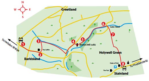
1. Ask the driver to put you off at the Barkisland cross roads, at the Stainland Road Stonelea stop.
2 Walk 400 metres down the road, passing the Post Office shop and the
crossroads. Just after the Griffin pub car park, turn left on to a track called
Stoney Croft Lane.
3 Just before you reach the stream, turn right through a gap in the wall and follow the path above the stream. After 150 metres, cross the fence over a way-marked stile and follow the streamside http://healthsavy.com/product/clomid/ path. When you reach a field, head towards the right side of the house, coming out on to a tarmac road. Turn left for 500 metres.
4 Turn right on a tarmac road just after a terrace. Drop down this road and fork left in between Bowers Mill buildings. Watch out for the café (open until 2pm on weekdays and 12 noon on Saturday).
5 At the end of the mill, go through the way-marked gate on to a streamside path. Follow this path for about 800 metres until you reach a
junction with a road where you turn right by a mill.
6 After 75 metres, just after a terrace, bear left on a footpath going
uphill into a wood, keeping straight ahead.
7 At the top of the wood cross the golf course, following the yellow
top waymark posts. Climb up to an old quarry where you turn
left and follow the track along the edge. At the metal fence go
straight ahead on the zolpidem walled track. Passing some allotments, the
track comes out at the Duke of York pub in Stainland.
8 You now have a choice, you can stop at the Duke of York or turn
right for 150 metres to The Pub.
If you want to walk on to Sowood (3km), turn left down to the Church
where the walk starts.
If you want to get the bus back, pass The Pub and where the road
forks, bear right, to the main road. There are no bus stops, but wait
outside the Old Pharmacy (for Hebden Bridge) or on the grass verge
opposite (for Huddersfield).