HEBDEN BRIDGE WALKERS ACTION
901 BUS WALKS 2
Cragg Vale to Todmorden along the
Calderdale Way
Main features of the walk This linear walk follows The Calderdale Way. It takes in the wooded valley of Cragg Vale before climbing out of the valley onto the open moors between Cragg Vale and the Calder Valley with far-reaching views of Stoodley Pike and beyond.
Length and time It's 9km (5½ miles) and should take you about 3 hours (plus stops).
Gradients – how strenuous? The outward walk involves a steady climb out of the valley .
Terrain – how uneven? Much of the high moorland is very uneven in places. Some of the walk is on farm tracks and lanes.
Obstacles – stiles, steps etc. There are a few sets of causey stones, some of which are quite uneven along with some stiles.
Facilities on the walk This walk passes by the Hinchliffe Arms and the Top Brink Inn. There are many pubs and restaurants in Todmorden.
What to take? This walk goes across high, exposed moorland so windproof/waterproof clothing is essential. You need a pair of reasonable walking shoes with 'grippy' soles (boots would be better) as parts of the route can be muddy after rain.
DIRECTIONS
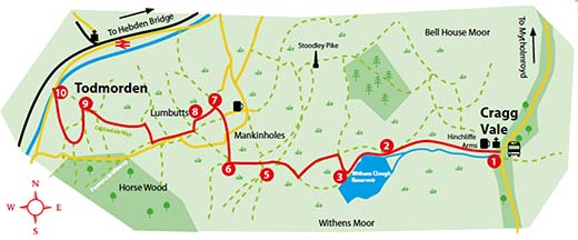
Ask the driver to put you off at the junction of Cragg Road and the road down to the Hinchliffe Arms. From the bus stop go down hill, cross the road before turning sharp left down to St. John's Church and the Hinchliffe Arms. From the pub follow the tarmac road uphill bearing left to go up Rudd Lane. Continue along the road for almost 2km to Withens Clough Reservoir. Pass the house called the Pastures and follow the track along to the right of the reservoir
2 Walk past the sign to "Stoodley Pike" and take the next path on the right, signed "Calderdale Way". Turn left at the Yorkshire Water Permissive Bridleway sign and follow the well-made track up the hill through two metal gates until you reach a wooden gate.
3 Go right through the gate signed Calderdale Way and follow the track uphill. Watch out on the right the for stone bearing the inscription 'Te deum laudamus' - we praise thee O Lord; and go through another gate at the top of the slope. Carry straight on following the stone guideposts with Stoodley Pike on the right.
4 As you start to go downhill, go straight over the junction with the Pennine Way and carry on downhill along the causey stone paved path.
5 At the gate turn right to go into Mankinholes village. Go through the village passing the Youth Hostel and the bus stop.
6 Opposite the converted Methodist Sunday School turn left down the Pennine Bridleway. At the Top Brink lnn, carry straight on down a cobbled path into Lumbutts village with its distinctive water tower.
7 On reaching the tarmac road, turn right and continue for 800 metres where you turn right at Croft Gate East signed Calderdale Way to Croft farm. Continue straight on through a metal gate onto a track. Follow this track for 100 metres and then cross the stile in the wall on the left. Keep the wall on your left to the next stile, then follow the way-marked path straight ahead, eventually reaching Longfield Farm.
8 Bear left through the farmyard and go left over a stile by electric pole 273, following a field path over a stile onto a track through the equestrian centre. Turn left on the drive, then right at the next T junction. Follow the track around the fields, dropping towards Todmorden in the valley below. At the bend is the Quaker burial ground. Continue down the lane to a tarmac road, passing the Unitarian Church on the left before entering Fielden Square Todmorden.
9 From Fielden Square, turn right on the main road and the bus terminus is straight ahead on the other side of the roundabout. There is a great choice of pubs and cafés in Todmorden at the end of your walk.