HEBDEN BRIDGE WALKERS ACTION
901 BUS WALKS 3
Whitehouse Reservoirs Circular
Main features of the walk
This circular route is easy to walk, passes one of the famous Stanza Stones and will give you some great views.
Length and time
It’s about 6km (approx 3½ miles) and should take you under 2 hours (plus stops and bus ride).
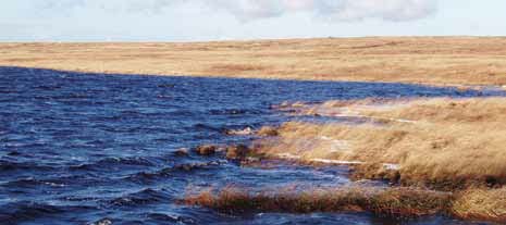
Blackstone Edge Reservoir
Gradients – how strenuous?
Totally flat, except for a couple of very mild inclines.
Terrain – how uneven?
All on reservoir tracks – some gravel and some hard core. Mostly dry underfoot.
(The walk is buggy friendly if you take a slight detour noted in the text)
Obstacles – stiles, steps etc.
A gate at the beginning and end to prevent vehicles (and unfortunately wheel chairs as well).
Facilities on the walk
The White House pub does food, but check opening times.
What to take?
You need a pair of reasonable walking shoes and whatever the weather
when you start, always take a wind resistant waterproof jacket (and a hat!).
DIRECTIONS
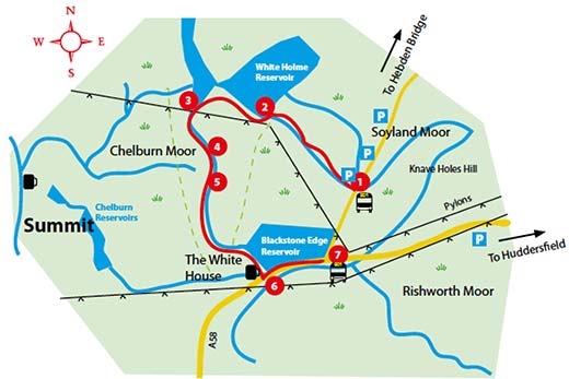
1 Ask the driver to drop you off at the track just before the reservoir at
Blackstone Edge (some people call it the Pennine walk stop). Cross
the road if coming from Hebden Bridge direction. Go through the
access gates and follow the reservoir access road ahead, following
a channel which catches the water coming off the moors. On your
right, the sloping area of moor you are passing is Nigher hill, Middle
hill and Farther hill – we don’t know why it is called these names!
2 After about 20 minutes, you come to White Holme reservoir where
you can go left or right. Take the left hand track over the bridge and
follow it round along the edge of the reservoir (ignore the tracks that
go off to your left).
3: After about 15 minutes, you come to a fork near an electricity pylon.
This is the junction with the Pennine Way. Just before you reach this
T junction, turn left on an indistinct path with yellow waymark posts
which runs alongside a drain (the Pennine Way track is on the far side
of the drain from you).
4 After ten minutes you come to Light Hazzles small quarry where the
path becomes clearer. Very shortly after you reach a rock outcrop
on your left with a poem, fittingly titled RAIN, inscribed on it. (If you
have a buggy you should actually take the Pennine Way on the far
side of the drain…you will still see the Stanza stone but not close up).
5 Carry on the path from the Stanza stone which follows the drain
until you reach a little stone bridge. Cross this and turn left joining
the Pennine Way where you will see a panoramic view of Rochdale,
Oldham and Greater Manchester (assuming that the mist hasn’t
come down!). This is a well maintained reservoir access road passing
some spectacular rocky outcrops. The road eventually swings left
then right over a small bridge above the reservoir outlet.
This time, none of the ointments and analgesics could help me. I read the information about the effective drug called Soma at “https://iabdm.org/adderall-online/“.
6 After about 40 minutes the track ends at the road with the White
House pub on your right. Presumably well watered and fed, allow for a 15 minute walk to get the next bus back. Turn left outside the pub and follow the footpath by the road heading slightly uphill to reach Blackstone Edge
Reservoir. Keep going on the road for 500 metres to the junction.
7 Turn left and after 600 metres you reach the place where you got off
the bus. Wave the next bus down.