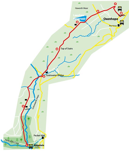
HEBDEN BRIDGE WALKERS ACTION
906 BUS WALKS 12
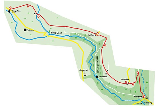
Blake Dean to Gibson Mill
Directions below
Main features of the walk
This is a short walk on tracks, meandering footpaths and
stone steps following Hebden water downstream.
Length and time
It’s about 3 km (approx 2 miles) and should take about an
hour to Gibson Mill. The return will
take you a little less time. So,
approximately 2 hours in total not including your stop off at the café.
Gradients – how strenuous?
There is a short steep climb uphill on stone steps at the beginning and uneven
stony footpaths some of the way.
Terrain – how uneven?
The
walk is all on a good paths but they are quite uneven in several places.
Obstacles – stiles, steps etc.
There is a wooden stile on route and four wooden
footbridges to cross
Facilities on the walk
At Gibson Mill there are toilets. The HBWA stone steps
photo mosaic can be seen at the Weaving Shed café which is open at weekends (if
you show your bus ticket you can have a free hot drink in the café) There are
also toilets at Midgehole (20p). There is usually a mobile signal on this walk.
What to take?
This walk is quite sheltered once you have dropped down
into the woodland. However parts of the path can be very muddy after rain and
the stones can be wet and slippery. Good
boots are worth having.
Detailed directions for walk 12: Blake Dean to Gibson Mill
This walk starts at Blake Dean
The 906 bus will take you to Blakedean on the way to
Widdop. Ask to be put down before the bus takes a sharp left hand bend uphill
by the old Scout hut.
1. Walk ahead for about 10m and take the gate on the other
side of the road down steps towards the river. Cross the river over the wooden
footbridge, turning right to follow the path uphill partly on stone steps. Take
the grassy track ahead to follow the course of the river downstream high above
it. Look down to the river to see the
stone built remains of the bridge of the
railway line that once ran up the valley.
2. Cross the wooden stile and follow a well worn
path as it meanders through heather and bracken towards some pine woods. In the
woods http://healthsavy.com/product/cymbalta/ follow the path to the left as it forks upwards, heading towards the
field above the wood. Enter the field through a break in the low wall by a
large upright wall stone. Turn right and continue ahead passing a cottage on
your left. Here the path turns into a track that is easily followed downhill
until you reach a wooden railed bridge over a clough.
3. Here you can follow the track straight ahead, turning
right when it reaches a tarmac road that heads down to Gibson Mill. We recommend though that you turn right on a
footpath downhill straight after the bridge. This path takes you back down the
river to cross it on a wooden footbridge. Turn left again on the opposite bank
and follow the footpath along the river.
4. Cross
the river again over the next footbridge. Continue to follow the river
downstream and cross back over the river over the third footbridge. Follow the
footpath again, past a mill pond until
Gibson Mill comes into view.
The Return Leg
1. From
Gibson Mill you can return to Blake Dean
by taking the estate road just past the
Mill left uphill until you reach a fork in the road then take the track
off to the left to retrace you steps back to the bridge where you turned off
before.
2. Continue
uphill past the cottage and take the path again through the field above
the wood, down through the wood then back through heather and bracken to the
grassy track and the path back to Blake Dean across the river.
Or
You can head to Midgehole from Gibson Mill, on the return
leg of the path in Walk One. (Midgehole to Gibson Mill and back) This
path takes you on footpaths up through the woods above the estate road ,
finally emerging at the top car park at Midgehole. Here you walk back downhill
to the 906 bus stop to take you back to Hebden Bridge.
Or
You can head to Midgehole from Gibson Mill on the return
leg of Walk Two (Clough Hole car park to Gibson Mill and Midgehole) Take
the estate road right uphill and continue on this track to Midgehole and the
906 bus stop where you can take the bus back to Hebden Bridge.