Author Archives: a1anpmcd0

906 BUS WALKS 9 Widdop to Holme Chapel via Pennine Bridleway

HEBDEN BRIDGE WALKERS ACTION

906 bus

906 BUS WALKS 9
Widdop to Holme Chapel
via Pennine Bridleway

Map and Directions below

Main features of the walk
This walk crosses wild moor land with craggy outcrops and several reservoirs. It is a well marked route, so is suitable for relatively inexperienced walkers. You also get to see the remains of hushings – an ancient mining technique.

Length and time
It’s about 12 km (8 miles) and should take you about 3½ – 4 hours (+ stops).

Gradients – how strenuous
There is one fairly short up hill at the start and a couple of gentle up hills later but most of the walk is gently down hill.

Terrain – how uneven
The walk is nearly all on good tracks with one stretch on a good footpath. The whole route is well signposted with Pennine Bridleway signs.

Obstacles – stiles, steps etc.        
Because it is a bridleway, there are several gates on the route.

Facilities on the walk
There are no facilities on the route, but the walk ends at Holme Chapel where you may want to visit the Ram Inn.

What to take
Whatever it feels in the valley, it can be very cold and windy on the moors so you must take good wind and waterproof clothing. Boots would be best but good walking shoes will be ok.

Detailed directions for walk 9 Widdop to Holme Chapel via Pennine Bridleway

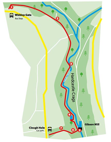
This walk starts at the 906 bus terminus at Widdop.

  1. From the car park you take a clear wide path towards the dam, passing through a gate, over a footbridge and up a few steps to the reservoir dam top.
  2. Turn left and walk across the dam to the other side where you turn right. Go through the gate (sign-posted Pennine Bridleway) by the pump house and walk ahead with the reservoir on your right.
  3. After 200 metres, ignore the footpath branching off uphill to the left and continue along the main track passing a conifer plantation to your left.
  4. At the end of the plantation, ignore the smaller track going off to the right heading for the water and continue the well made track up which winds up quite a steep incline for 1km (there are good http://healthsavy.com/product/phentermine/ views of the reservoir behind you).
  5. At the top, the track straightens out, reaching a signpost ‘Pennine Bridleway Worsthorne 3 miles’ where you keep straight ahead and starting to descend.
  6. After 1km you go through a metal gate and after another 1km you pass a signpost ‘Pennine Bridleway MT Loop West’.
  7. After 250 metres you turn left at the signpost ‘Pennine Bridleway Hurstwood Reservoir ¼ mile’, heading towards the reservoir. (Note the strange landscape on your left cause by hushing, described later).
  8. The track passes another signpost ‘Pennine Bridleway’ and heads along the left hand edge of the reservoir until you reach the dam wall at the far end.
  9. Bear left on the track signposted ‘Pennine Bridleway Long Causeway 1½ miles’.  Ignore the track going up to the electricity pylon.
  10. Towards the top of the slope you reach a plateau where the track bears right (Cant Clough reservoir comes into view almost immediately).
  11. At the reservoir, go straight across the dam, then continuing on the track by the side of a fence. Cross a stream and turn left at the signpost ‘Long Causeway ½ mile’.
  12. You now follow an old walled track, re-crossing the stream twice. You pass an information board ‘Shedden Clough and the Hushings’ then go straight up hill until you reach the main road.
  13. At the road turn right along the side of the road and cross at the signpost ‘Holme Chapel’.  Go through the gate, turn right on the path.
  14. Go through the fenced hedge and turn left on the path following the fence downhill. The path moves away from the fence, goes through a gate heading down hill and joins a hedge where you turn right.
  15. When you reach a T junction near a wooden fence, turn left, heading down towards a signpost ‘Pennine Bridleway Holme Chapel ½ mile’.
  16. Follow the walled track ahead until you reach a minor road where you turn left down into Holme Chapel.

From Holme Chapel you can get the 592 bus back to Hebden Bridge or buses to Todmorden and change. The Ram is dead opposite the bus stop.

906 BUS WALKS 8 Midgehole to Lumb Falls and back

HEBDEN BRIDGE WALKERS ACTION

906 bus

906 BUS WALKS 8
Midgehole to Lumb Falls and back

Directions below

Main features of the walk
This walk gives you some fantastic panoramic views of Crimsworth Valley and an opportunity to visit Lumb Falls, a local beauty spot and Pecket monument

Length and time
It’s about 6 km (just under 4 miles) and should take you about 2½ hours (plus stops)

Gradients – how strenuous
The outward walk is a moderate uphill climb, dropping down steeply to the stream and up the other side. The return is mainly flat or gentle down hill

Terrain – how uneven
Most of it is on good tracks with a few sections of footpath. Some parts of the walk may be very muddy, especially after rain.

Obstacles – stiles, steps etc.        
There is one stretch of steep up hill on a cobbled path and several stiles and gates on the return route

Facilities on the walk
A great seat at Lumb Falls to eat your lunch or have a snack, toilets (20p) and Blue Pig working men’s club at Midgehole. There is limited mobile signal on this walk.

What to take
You need a pair of reasonable walking shoes; even if you set off in fine weather (and a stick may be useful on a couple of muddy bits), best to take a sandwich and drink.

If you want to walk back to Hebden Bridge from Midgehole, pick up a copy of ‘Three way-marked walks from Hebden Bridge’ from Hebden Bridge Visitors Centre. This has a description of the route.

Detailed directions for walk 8 Midgehole to Lumb Falls and back

  1. From the 906 bus stop at Midgehole take the bridleway on your right just after the Welcome to Hardcastle Crags sign. At the top of this walled path, turn right on to the track (initially tarmac). From here you follow this track straight ahead (ignore turnings off) for 1½ km, it’s a steady climb, through some woodland on to upland grazing.
  2. You pass Laithe farm on your right and 150 metres before the next set of buildings, you take a bridleway bearing off to your right, sign-posted Lumb Bridge. At the stream, turn right past the ruined building called Sunny Bank, then follow the path down to Lumb Falls where you may want to linger a while.
  3. After the bridge, the path doubles back, passing the Ted Hughes Six Young Men plaque, and then http://healthsavy.com/product/soma/ going up the steep cobbled packhorse path to the left.
  4.  At the top, turn right along the tarmac Haworth old Road and follow it for about ¾km (there should be very little traffic as it is a dead end).
  5. 100 metres before the road joins the main road (you will see a bus stop in the distance), you take a way-marked tarmac lane bearing off to your right between two walls. The lane bends to the right and when you are opposite the house on your right, look for a path off to the left going through a small stone stile.
  6. Go straight ahead, past a farm on your left and follow the wall to a gap stile by a house. Here you follow the well marked route around the bottom of the garden
  7. Cross back up to follow the wall, going through two small gates into a garden. Cross the garden and exit by a small stile bringing you out on a track.
  8. Turn right and go down towards the houses. Go to the left of the house on a way-marked bridleway and go through 2 wooden gates to the field. Turn left and follow the wall along, through metal gates and gap stiles until you come out on a track where you turn right down hill to a cluster of dwellings.
  9. At the houses, the track turns left through a gateway and you immediately take a path on your right way-marked Monument and Midgehole. Follow this path downhill and keep heading for the monument where you may want to rest awhile and admire the view.
  10. Head down to the bottom left hand corner of the field through a gap stile into National Trust’s Pecket Well Clough. Follow the path straight ahead downwards, alongside the fence for about 100 metres (take care on the short steep section) and you join a track where you turn sharp right.
  11. This track is an old packhorse route which you follow all the way back to Midgehole. When you arrive at the bottom by a house keep straight ahead and you will come out at the toilets at Midgehole.

If you want to walk back to Hebden Bridge, Hebden Bridge walkers Action have produced a guide to the route

906 BUS WALKS 7 Packhorse Inn to Hebden Bridge via Colden

HEBDEN BRIDGE WALKERS ACTION

906 bus

906 BUS WALKS 7
Packhorse Inn to Hebden Bridge via Colden

Directions below

Packhorse Inn to Hebden Bridge via Colden

Main features of the walk
This is a relatively easy walk with fantastic views of the upland landscape and two of the main valleys in the area.

Length and time
It’s about 10 km (about 6½ miles) and should take you about 3 hours (+ stops).

Gradients – how strenuous
Most of the walk is on the flat or gentle inclines with one short uphill and downhill at the start.

Terrain – how uneven
This walk is on a clear path with most of it on good tracks.

Obstacles – stiles, steps etc.        
There are two stiles and two gates .

Facilities on the walk
There is a pub at the beginning, half way through and loads of cafés pubs and eateries at the end in Hebden Bridge.

What to take
It can be windy at this height and there is very little shelter, so take warm/wind proof clothes even if it’s a sunny day. The walk is on good surfaces so a good pair of walking shoes would be adequate. Take a copy of the Hebden Bridger E bus timetable in case you want to shorten the walk at Jack Bridge.

Detailed directions for walk 7 Packhorse Inn to Hebden Bridge via Colden

  1. This walk starts at the Packhorse Inn (where you might have lunch before you set off). Carry on down the road away from Hebden Bridge for 150 metres and take the footpath on the left, going over the ladder stile by a signpost.
  2. Follow the path by the wall downhill until you reach a stile, coming out on to the Pennine Way. Cross the stile turning left and head down hill. After 20 metres fork right, passing through a gate down to path by the side of Graining water, still following the Pennine Way.
  3. Cross the two bridges and take the path heading up hill through the stone gate posts. The path heads up to the left of Gorple Cottages and crosses a track by a 4 way signpost. Go straight https://www.sleepprointernational.com/products/ambien/ across, now on a track buy cialis no prescription through a pair of metal gates signposted Pennine Way and Pennine Bridleway. After 250 metres go through a gate and go straight ahead signposted Pennine Bridleway.
  4. As you come over the crest of the hill, Noah Dale comes into sight straight ahead and, if you look to your right you will see the remains of Reeps cross. The track now drops down to a gate where you go straight ahead, sign-posted ‘Pennine Bridleway – Blackshawhead 2 miles’. After 1km the surface of the track becomes tarmac.
  5. After ½ km the Pennine Bridleway turns sharp right, but you carry straight on, (300 metres down the Pennine Bridleway is Land Farm, a delightful open garden, so a detour may be in order).
  6. Heading straight on, 100 metres on your left , you pass a row of cottages and then immediately take a track going down off to the right. The track passes some houses on your right and then bends down to the right then winding through a series of dwellings until it reaches the Blackshaw Road at a bus stop.
  7. Here you can get a bus back to Hebden Bridge or if you turn right down the road for about 300 metres to Jack Bridge and the New Delight Inn where you might want to take a break.
  8. Coming out of the New Delight, turn right uphill and after 50 metres take the track on your left signposted Pennine Bridleway to Callis Bridge.
  9. Keep straight ahead on this track (ignore all turnings off) until after 2km you come out on a tarmac road. Go down this road, past the church until you reach the main road. Cross the road (be careful and use the island) and go through a gap in the wall, down a set of steps and follow the path along Colden water. Cross the bridge and go straight ahead where, after 50 metres you come out on the Rochdale canal.
  10. Turn left along the towpath and Hebden Bridge town centre is about 1km walk

906 BUS WALKS 6 Midgehole to Oxenhope via Haworth Old Road

HEBDEN BRIDGE WALKERS ACTION

906 bus

906 BUS WALKS 6
Midgehole to Oxenhope
via Haworth Old Road

Map and Directions below

Main features of the walk
This walk follows the old route that connects the Calder and Aire Valleys. It has fantastic panoramic views of both valleys.

Length and time
It’s about 10 km (approx 6½ miles) and should take you about 3 hours (+ stops).

Gradients – how strenuous?
There are two longish climbs and two descents.

Terrain – how uneven?
The walk is all on well signposted tracks, but some parts can be very muddy.

Obstacles – stiles, steps etc.        
There are a number of gates on the route.

Facilities on the walk
There are toilets at the start at Midgehole (20p). Otherwise, are no facilities on the route, but the walk ends at Oxenhope where you may want to visit the Station café or one of the two village pubs.

What to take?
Because of muddy sections, you really need boots for this walk. It is quite exposed on the top of the walk, so make sure you have clothing to deal with wind and rain. Also take a timetable for the 500 bus to bring you back to Hebden Bridge.

Detailed directions for walk 6: Midgehole to Oxenhope via Haworth Old Road

This walk starts at the 906 bus stop at Midgehole.

906_map6

  1. Take the bridleway on your right just after the Welcome to Hardcastle Crags sign. At the top of this walled path, turn right on to the tarmac track. From here you follow this track straight ahead for 2½ km. It’s a steady uphill climb through some woodland on to upland grazing.
  2. You pass Laithe farm on your right, then a derelict farm on your left (can be muddy) and then, still on the track,  gently drop down to a bridge where you go straight ahead.
  3. When you reach the tarmac road, you turn left heading uphill sign-posted ‘Calder Aire Link Bingley 13 miles’. There is now a 1km steady climb to ‘Top of the Stairs’ (ignore tracks going off to the left and right).
  4. At the top, the track levels out and follows a wall and the Aire Valley comes into view. From here the track gently descends through a gate and then goes down more steeply, past a farm on your left.
  5. Reaching Lower Laithe Reservoir, the track bears right and then left below the dam, eventually coming out on a tarmac road by the reservoir gates where you turn right.
  6. After ½ km, at a cross roads, you go straight ahead on to Marsh Lane. Having passed a chapel, and after another ½ km, you reach a road on your right, sign-posted ‘Oxenhope and Hebden Bridge’.
  7. The bus stop for the 500 bus back to Hebden Bridge is 100 metres farther on.

If you have a wait for the bus, you may want to take the right turning which drops down to Oxenhope Station (10 mins walk) where there is a great café and another 500 bus stop. If you prefer a pub, ignore the station and continue straight ahead uphill and you will come out near to the Bay Horse Inn and another 500 bus stop.

906 BUS WALKS 5 Clough Foot to Haworth via Pennine Way and Brontë Way

HEBDEN BRIDGE WALKERS ACTION

906 bus

906 BUS WALKS 5
Clough Foot to Haworth
via Pennine Way and Brontë Way

Map and Directions below

Main features of the walk
This walk combines the well marked Pennine Way and the Brontë Way. You will see beautiful moorland scenery. You pass Top Withens (the ruined farmstead which was the possible inspiration for Emily Brontë), Brontë Falls, Haworth Parsonage and of course Haworth itself.

Length and time
It’s about 10½ km (6½ miles) and should take you about 2½ – 3 hours (+ stops)

Gradients – how strenuous?
There is a gradual ascent from the road to the first reservoir and from the second reservoir to Top Withens. Once over Brontë Bridge, there is a gentle incline followed by a long traverse.

Terrain – how uneven?
Some concrete roads but then a lot of moorland scrub in-between the paved path.

Obstacles – stiles, steps etc.        
There are some steps, both for ascent and descent and parts of the route are uneven.

906_05_01

Facilities on the walk
There are great places to have a picnic along the way. The walk ends at Haworth where you will find many cafés, pubs and eateries.

What to take?
You will need boots or good walking shoe. It can be windy so take wind and rain proof clothing. Take a 500 bus timetable with you.

Detailed directions for walk 5: Clough Foot to Haworth via Pennine Way and Brontë Way


906_map5

This walk starts at the 906 bus stop at Clough Foot.

  1. Go through the green metal gates which are on the right hand side of the road in the direction of bus travel and follow a tarmac road sign-posted ‘Pennine Way’.
  2. At the fork, keep left. At the first reservoir turn right to cross the reservoir dam, sign-posted ‘Top Withens 3 miles’.
  3. Once across the dam, turn left, following the path, way-marked PW (Pennine Way).
  4. At the next http://healthsavy.com/product/diflucan/ reservoir dam, follow the signpost ‘Pennine Way’, keeping on the left side of the drain after crossing the little bridge.  Continue following the Pennine Way signs ‘Top Withens’.
  5. Half way along the second reservoir, the footpath meets a track. Follow the track uphill through a metal gate. At the signpost, some 100m ahead, bear right up the slope.  As you climb, take the paved path bearing to the right.  As you crest the hill, Top Withens will be clearly visible on the left of the path ahead.
  6. Continue past Top Withens and another ruined farmstead on the left, turn right to follow the Brontë Way path, signposted ‘Haworth and Brontë Falls’.
  7. The Brontë Way is popular and easy to follow. It crosses a stream, moorland and an open field, before eventually dropping down to a three way signpost next to a kissing gate. Here, you turn right through the gate, downhill to the Brontë Bridge.
  8. After the Bridge, turn left and follow the footpath uphill where it merges with a track that leads to the minor road, Moorside Lane.
  9. Turn right up the road, then turn left at the signpost ‘Public Footpath Urban Commons’ on to Penistone Hill Country Park.At the top of the slope, turn left to rejoin the
    Way, signposted to Haworth.
  10. Continue on this path until you reach a minor road, Dimples Lane. Go straight across the road to pick up the walled lane opposite.
  11. At the bottom of the lane, turn left at the signpost ‘Haworth’ following a paved path which brings you to the Church and your destination.

From Haworth, you can get the hourly 500 bus back to Hebden Bridge. The stops are at the bottom of the main street opposite the Old Hall pub and opposite the railway station.

906 BUS WALKS 4 Clough Foot to Midgehole via Walshaw and Shackleton

HEBDEN BRIDGE WALKERS ACTION

906 bus

906 BUS WALKS 4
Clough Foot to Midgehole
via Walshaw and Shackleton

Map and Directions below

Main features of the walk

This is a relatively straightforward way to experience fantastic views of the upland landscape.

Length and time
It’s 7 km (4½ miles) and should take you about 2½ hours (+ stops).

Gradients – how strenuous?
Most of the walk is on the flat with a short incline at the start and a downhill stretch at the end. It would be feasible to do this walk with an all terrain buggy.

Terrain – how uneven?
This walk is all on good tracks.

Obstacles – stiles, steps etc.
There are no obstacles.

Facilities on the walk
There are toilets (20p) at the end of the walk at Midgehole. There is usually limited mobile signal on this walk.

What to take?
It can be windy at this height and there is very little shelter, so take warm/wind-proof clothes, even if it’s a sunny day. The surface is good, so walking shoes would be fine.

If you want to walk back to Hebden Bridge from Midgehole, pick up a copy of ‘Three way-marked walks from Hebden Bridge’ from Hebden Bridge Visitors Centre. This has a description of the route.

Detailed directions for walk 4: Clough Foot to Midgehole via Walshaw and Shackleton


906_map4

This walk starts at the 906 bus stop at Clough Foot car park.

  1. Cross the road and take the footpath signposted ‘Walshaw Reservoir 1½ miles’. After 50 metres turn right through a metal gate and turn left on to the tarmac road.
  2. After 800 metres, cross a cattle grid and take the right hand fork. Go down the concrete track, passing below a ruined house. Cross the double arched bridge over the River Alcomden and follow the track http://healthsavy.com/product/valium/ uphill to the right.

From here you follow this same track for 5km, but in detail…..

  1. After 1 km, near a barn, you use a small gate just on your right and immediately rejoin the track.
  2. After 1 km, you come to the small hamlet of Walshaw which Lord Saville used for entertaining shooting parties. Keep on the track as it winds through the hamlet, ignoring tracks going off both sides.
  3. After ½ km, where the track forks you keep straight ahead signposted ‘Hardcastle Crags via Shackleton’. To your right, you should be able to see the top of the Hardcastle Crags in the valley below.
  4. After 1 km you pass between a couple of farms and then after another 1 km you arrive at the hamlet of Shackleton, with its green painted doors and windows.
  5. Just after Shackleton you can see four major landmarks. The mill chimney ahead is at Pecket Well, to the right is the mill chimney at Old Town, further round on the near horizon is the top of Heptonstall Church and to the right again is Stoodley Pike.
  6. The track descends into National Trust woodland arriving at a T junction with a bench. Here you follow the track heading downhill to your right.
  7. Continue down this track until you come to two car parks. Take the path heading downhill on your left (just before the car parks). When you come to a road you will see the toilets and the 906 bus stop for Hebden Bridge is on your left.

If you want to walk back to Hebden Bridge, Hebden Bridge walkers Action have produced a guide to the route

906 BUS WALKS 3 Widdop Gate to Gibson Mill via old railway and stone steps

HEBDEN BRIDGE WALKERS ACTION

906 bus

906 BUS WALKS 3
Widdop Gate to Gibson Mill
via old railway and stone steps

Map and Directions below

Main features of the walk
This is a short circular walk mainly in woodland and partly following the route of an old railway line used to build local reservoirs.

Length and time
It’s about 3km (approx 2 miles) and should take you about 1½ hours (+ stops).

Gradients – how strenuous?
This walk is mainly a gentle descent with two steep flights of stone steps – one up and one down.

Terrain – how uneven?
The walk is all on a good paths but they are quite uneven in several places.

Obstacles – stiles, steps etc.
There are two stiles with gate alternatives.

Facilities on the walk
At Gibson Mill there are toilets, the HBWA stone steps photo mosaic and the Weaving Shed café (if you show your bus ticket you can have a free hot drink in the café). There are also toilets at Midgehole. There is usually no mobile signal on this walk.

What to take?
The walk is quite sheltered, but parts of the path can be pretty muddy, especially after rain, so you need some decent footwear

Detailed directions for walk 3: Widdop Gate to Gibson Mill via old railway and stone steps

This walk starts at the 906 bus stop at Widdop Gate.

906_map3

  1. Cross the road and walk back ten metres to take a way-marked path through a wooden gate. The path drops down and then becomes a set of stone steps. At the bottom of the first flight, turn right at a signpost. You are now on the route of an old railway line.

A note about the railway line

The railway was built in about 1900 to bring materials for the construction of the reservoirs higher up the hillside. The stream at Blake Dean, in front of you was crossed by a huge wooden trestle bridge regarded locally as the eighth wonder of the world.

  1. After ½ km you reach a signpost where you keep straight ahead. Shortly after, the path begins to go gently downhill.
  2. After ½ km the path reaches the river which you now follow downstream on a partly paved rough path.
  3. After another ½ km you reach a mill pond which you walk around. At the far end of the pond, take a set of stone steps and continue following the river. After 200 metres you arrive at Gibson Mill, where a stop for refreshment would be in order.
  4. You now have a choice: to finish the walk will take you about 25 minutes to get up to the bus stop at the Clough Hole National Trust car park, so check the timetable and if it fits, fine. If there’s a long wait, you might want to consider walking down to Midgehole bus stop, using the routes from Walks 1 and 2.
  5. Return over the bridge and take the fantastic flight of stone steps opposite. At the top of the steps you arrive at a path where you turn right. This path joins a track, where you turn right again, heading uphill.
  6. Pass through two stiles by gates and then take the short flight of steps up to Clough Hole car park where you can catch the 906 bus back to Hebden Bridge.

906 BUS WALK 2 : A gentle walk from Clough Hole car park to Gibson Mill and Midgehole

HEBDEN BRIDGE WALKERS ACTION

906 bus

906 BUS WALK 2
Walk 2: A gentle walk from Clough Hole car park
to Gibson Mill and Midgehole

Map and Directions below

Main features of the walk
This woodland walk drops down to Gibson Mill and along to Midgehole.

Length and time
It’s about 3 km (approx 2 miles) and should take you about 1- 1½ hours.

Gradients – how strenuous?
The first part of the walk from Clough Foot National Trust car park to Gibson Mill is quite a steep downhill. The track from Gibson Mill to Midgehole is easy going with a gentle incline and descent.

Terrain – how uneven?
This walk is all on good tracks that are suitable for people who find uneven terrain difficult. It may be possible to do this walk with an ‘off road’ buggy with large wheels.

Obstacles – stiles, steps etc.
There are a couple of stiles with alternative gate access.

906_02_01

Facilities on the walk
At Gibson Mill there are toilets, the HBWA stone steps photo mosaic and the Weaving Shed café (if you show your bus ticket you can have a free hot drink in the café). There are also toilets at Midgehole. There is usually no mobile signal on this walk.

What to take?
Some of the track down may be a bit muddy after rain, so you need a pair of reasonable walking shoes; even if you set off in fine weather.

Detailed directions for walk 2: Clough Hole car park to Gibson Mill and Midgehole

The 906 will take you to Clough Hole National Trust car park on the Widdop Road where the walk starts.

906_map2

  1. From the car park, take the sign-posted steps or the path behind the car park ticket machine; both join the track heading down hill.
  2. Pass through two gates (or use the stiles) to enter woodland and follow the wide track for 300 metres until you reach a junction.
  3. At the junction, you turn sharp left, heading downhill’ sign-posted Gibson Mill. The track comes out of the wood, passing the toilets and on to the bridge at Gibson Mill.
  4. Before you leave Gibson Mill, we suggest that take a detour to see the mill pond located behind the mill. Go out of Gibson Mill, go straight ahead and then turn left alongside the Mill. After 50 metres you will see a footpath going off to the left which will take you to the mill pond. From the end of the Mill Pond you will get the best view of Gibson Mill.

A note about Gibson Mill
Gibson Mill produced cotton cloth from about 1800 until it closed in 1890.
After it shut down as a working mill, it became an “entertainment emporium” known as “Little Switzerland” with a cafe, dance hall and roller skating rink until it closed in 1945.

  1. Return to the entrance of Gibson Mill and take the track sign-posted ‘Car Park’. It starts off with a gentle uphill climb, but then levels out. After about 1km the track begins to descend to the main entrance of Hardcastle Crags where you keep straight ahead (ignore the track heading up to the left).
  2. You come out to a car park near the main entrance to Hardcastle Crags, with the toilets and the 906 bus stop back to Hebden Bridge a few metres ahead.

If you want to walk back to Hebden Bridge, Hebden Bridge walkers Action have produced a guide to the route

906 Bus Walk 1: Midgehole, Gibson Mill and back

HEBDEN BRIDGE WALKERS ACTION

906 bus

906 BUS WALKS 1:
Midgehole, Gibson Mill and back

Map and Directions below

Main features of the walk
This circular walk takes you through the delightful wooded valley of Hardcastle Crags, along a riverside path and back through woodland above the valley. There is the added attraction of visiting Gibson Mill.

Length and time
It’s about 5km (approx 3 miles) and should take you about 2 hours (plus stops).

Gradients – how strenuous?
The outward walk along the riverside has a couple of short climbs but mainly is on the flat. The return walk also has two quite steep climbs.

Terrainhow uneven?
Both the outward and return walks are very uneven in places. One or two spots are likely to be a bit muddy and slippery after rain (especially the outward riverside route).

Obstacles – stiles, steps etc.
There are a few sets of steps, some of which are quite uneven.

906_01_01

Facilities on the walk
This walk has National Trust red arrow waymarks along the route. At Gibson Mill there are toilets, the HBWA stone steps photo mosaic and the Weaving Shed café (if you show your bus ticket you can have a free hot drink in the café). There are also toilets at Midgehole. There is usually no mobile signal on this walk.

What to take?
You need a pair of reasonable walking shoes with ‘grippy’ soles as parts of the route can be muddy after rain. If you want to walk back to Hebden Bridge from Midgehole, pick up a copy of ‘Three way-marked walks from Hebden Bridge’ from Hebden Bridge Visitors Centre. This has a description of the route.

Detailed directions for walk 1: Midgehole to Gibson Mill and back

The 906 will take you to the Midgehole car park at the entrance of Hardcastle Crags where this circular walk starts. Most of this route has National Trust red arrow waymarks.

map

  1. Walk up the main track and after 30 metres you take a path on the left signposted Mill Walk and Picnic Area. This path joins the way-marked path which follows the riverside.
  2. After 50 metres the path goes up a set of rough stone steps on to the flat. You can stay up on the way-marked http://healthsavy.com/product/synthroid/ path, but it is more interesting to take the set of wooden steps back down to the riverside path which goes through a stand of pines, but then you have to go up some more steps to rejoin the way-marked path.
  3. Keep on this path as it winds and undulates through the woods always following the river.
  4. There s a short section along the riverbank where you need to take care as it can be slippery, especially after rain. The path then climbs up above the river.
  5. A little further on, the path turns sharp left back down to the riverside and a set of stepping stones. Carry on upstream on the way-marked path until you reach Gibson Mill. This stretch of the walk should take you about an hour.

A note about Gibson Mill
Gibson Mill produced cotton cloth from about 1800 until it closed in 1890. After it shut down as a working mill, it became an “entertainment emporium” known as “Little Switzerland” with a café, dance hall and roller skating rink until it closed in 1945.

The return leg

  1. From Gibson Mill, take the estate road which heads back to Midgehole sign-posted Car park. After 100 metres take a path off to the left, going uphill and sign posted ‘Mill Walk’. The rough path with some stone steps climbs steeply. After about 15 minutes you near the top of the trees and the path levels out.
  2. After about 250 metres the path descends through some Larch woods towards the main track to Gibson Mill. Just before you reach the track you take a way-marked path bearing left through the woods. 100 metres later, the path turns left at a way-mark and climbs to some large boulders.
  3. As the path levels out, it first bears to the right, continues through the woods, then turns left uphill, finally meeting a paved packhorse path, where you turn right downhill.
  4. The stone path goes to the right along a walled path between two fields. It comes out at a National Trust car park. Here you turn right down the track leading to the start of the walk and the 906 bus stop.

Facilities for walkers

Food and drink
Hebden Bridge has a very wide selection of cafes (17 at the last count), restaurants (from Bistro to fine dining), take aways (Indian, Chinese and italian) and pubs – most of which provide food. Most of these food outlets will have a Walkers are Welcome sign, so muddy boots shouldn’t be a problem.

There are several micro breweries around and most pubs you go to will have a good range of guest beers and ciders (BLM).

You can see some of the variety of places to eat and drink on our local Dining Guide website.

There are also a good selection of supermarkets and great speciality food shops to replenish your supplies (but let that prevent you from visiting Mays shop shortly after you rejoin the Pennine Way).

Information Sources
The town has a visitors centre to advise you on accommodation, directions or what souvenirs to buy (Butlers Wharf, New Road). 01422 843831, hebdenbridge@ytbtic.co.uk

There are two walking information boards in the town, one at the railway station, the other in the town centre car park (and of course look at other pages on our website).

For more information about what goes on in the town look at our community website, the HebWeb at www.hebdenbridge.co.uk

Dead useful stuff

  • There are three shops for emergency replacement of gear -Mountain Wild on Crown Street and Rohan in St Georges Square,
  • In case you need to dry out the laundrette with dryer is in Bridgegate
  • There is a Post office in Holme Street to buy stamps for the postcards you forgot to buy
  • There are several cash points (Coop store and off main square)
  • There are 2 bookshops for maps and guides –The Bookcase, 29, Market Street and Just Books, Bridgegate
  • 2 taxi firms at (01422) 844070 and 845555,
  • Car hire at star garage 842566
  • The nearest vet is a couple of miles away 01422 889970

Health and well being

  • Two chemists (Crown Street and Valley Road)
  • A doctors surgery (Valley road), Tel 01422 415777
  • A dentist (New Road) Tel 01422 843162
  • Two chiropodists for foot repair; Wendy Waterhouse Tel 07437 015754; Jean Wilding 01422 846131 and 07703 183810
  • A physiotherapist/sports injury specialist, Tel 07769 115 412
  • A chiropractor for a sore back, Tel 01422 842244
  • Several places to get your weary body a massage. Tel 01422 845880; 07952 671235; 07981 931853; 01422 843777
  • There are 8 hairdressers in the town
  • Many hairdressers do nails but you can also go to Smudges Nails 01422 847107

Staying overnight
Accommodation

For an evening’s entertainment we have:

Learning walking and compass skills

Splat training is based at Blackshaw Head, near Hebden Bridge, offering Hill Skills and Navigation, fun Guided Walks and First Aid training courses locally. For more details, look at their website