Category Archives: 901 bus walks

More information about the 901 bus

TimetablesA 901 timetable can be picked up from Calderdale Tourist Information
Centres, Halifax, Huddersfield and Todmorden bus stations and Hebden
Bridge, Huddersfield and Todmorden railway stations.

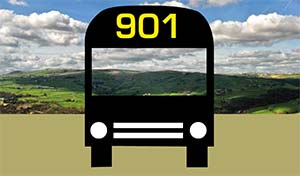
The 901 timetable can also be downloaded from the Metro website here.

If you are not sure which stop to get off, ask the bus driver who will know where your walks start.

Before you set off

Always wear good walking boots or shoes and take some waterproof clothes with you: the weather can change quite quickly on the tops. Make sure you have a copy of the 901 bus timetable (and any others you might need for returning to your destination).

Check the opening times of cafés and pubs on the route. Just in case, always take a drink ambien online and a snack. If you have the South Pennine Ordnance Survey map, bring it with you, even on the routes with maps.

Be aware that mobile phone signals come and go in this area.

Trains
For timetables to and from Hebden Bridge click here or phone
08457 48 49 50.

Buses
For details of the 901 and other local buses go to the Metro website
?? Phone 0113 245 7676.
?? Pick up timetables from Hebden Bridge or Huddersfield railway stations or Hebden Bridge Visitor Centre.

Key pubs and cafés
(Check opening times, especially in the winter)
Robin Hood Cragg Vale
01422 885899
Hinchliffe Arms, Cragg Vale
01422 883256
The Whitehouse, Blackstone http://healthsavy.com/product/cipro/ Edge
01706 378456
The Milestone Inn, Ripponden
01422 822821
The Old Bridge Inn, Ripponden
01422 822595
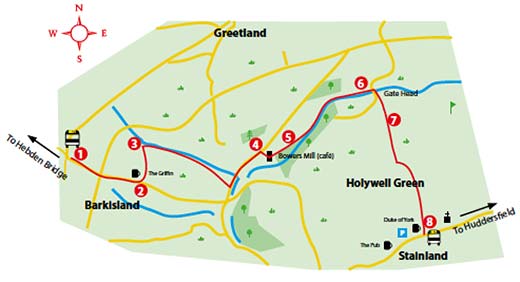
The Griffin, Barkisland
01422 823873
Bower’s Mill Café, Barkisland
01422 376755
The Pub, Stainland
01422 310099
The Duke of York, Stainland
01422 370217
The New Inn, Sowood
01422 310937

More walks around Hebden Bridge

If you have enjoyed these walks, we
have produced a range of other walks:

?? Twelve walks from the 906
summer bus to Hardcastle Crags
and Widdop

?? Three way-marked walks from
Hebden Bridge to Stoodley Pike,
Heptonstall and Hardcastle Crags
(this can be an add-on to the 906
walks that end at Midgehole)

?? Gentle walking – a series of easy
walks for people who are not very
fit or have a health condition

?? A short walk around Eaves Wood.
All these are available from Calderdale
Visitor Centres and walking shops.

For other self guided walks in the area,
look at these websites:

Feedback and corrections

Tell us about your experiences of
doing the walks – good and bad.
All the walks have been thoroughly
checked, but if errors have crept
in, please tell us. Contact us here.

Thanks

First, thanks to Metro for
supporting the 901 bus and for
providing finance to promote the
route.
Thanks to CROWS who checked all the
routes and sorted out way-marking
and drainage problems.

Design: frogsdesign

Photos: Graham Ramsden/Mike Barrett

Print: The Print Bureau

Website: Pennine Pens

Thanks to all the friends of Hebden
Bridge Walkers Action who walked out
the routes to check directions (often in
cold rain and mud!).

901 BUS WALKS 12 Stainland to Sowood

HEBDEN BRIDGE WALKERS ACTION

901

901 BUS WALKS 12
Stainland to Sowood

Main features of the walk
This walk is in a rarely walked part of the area, you may see deer, you will get some great views and you are only a stones throw from Huddersfield.

Length and time
It’s about 3km (approx 2 miles) and should take you about 1 hour (plus stops). You may want to join this walk with the one from Barkisland to Stainland making a total of 8km (5 miles)

Gradients – how strenuous?
Most of the walk is flat or gently down hill, with about 1km uphill at the end

Terrain – how uneven?
The first half of the walk is on farm a good track, the remainder is on good footpaths

Obstacles – stiles, steps etc.
There are a couple of gates and a stile.

Facilities on the walk
There are three pubs at the start and the New Inn at Sowood at the end

What to take?
You need a pair of boots or reasonable walking shoes with ‘grippy’ soles as parts of the route will be muddy, especially after rain.

DIRECTIONS

Take the 901 bus from Hope Street in Hebden Bridge.

  1. Ask the driver to put you off at the stop for Stainland (near the school)
  2. Walk past the school keeping it on your right. At the junction turn right along Bowling Green road and at the next junction turn left on to ativan online Stainland Road.
  3. After 700 metres, just before the church, fork right on a track called Carr Hall Lane. Follow this bridleway for 750 metres, and just after Castle Farm (fenced with security cameras), turn right through a tall metal gate on to a footpath.
  4. Cross a stream and follow the footpath up hill and at a fallen tree walk into the woods heading diagonally uphill towards another tall metal gate. Follow the path ahead and drop down, crossing the stream and a stile.
  5. Follow the path to the left, going uphill to some steps to the right of a wall. Continue on the path following the wall to a metal gate and just after it bends sharply to the left it arrives at a junction where you turn right on to a track. After 300 metres the track joins New Road at Sowood.
  6. Turn right on the road and the 901 bus stops are close by or you can cross the road and head straight uphill on a grassy path that leads you to Forest Hill Road. The New Inn is to the just to the left.

Check the bus times to get a return bus.

901 BUS WALKS 11 Ripponden to Stainland

HEBDEN BRIDGE WALKERS ACTION

901

901 BUS WALKS 11
Ripponden to Stainland

Main features of the walk
This walk takes you through many different landscapes with great views.
The walk is mainly along isolated lanes, passing some interesting
buildings and sweet streams.

Length and time
It’s about 11km (approx 7 miles) and should take you about 3½ hours (plus stops).

Gradients – how strenuous?
The walk has several descents into river valleys and climbs back up.

Terrain – how uneven?
This walk is mostly on tracks and lanes, with the rest on good footpaths.

Obstacles – stiles, steps etc.
There are several stiles on the route.

Facilities on the walk
This walk has no facilities on the route but refreshments are available at both ends

What to take?
You need a pair of reasonable walking shoes with ‘grippy’ soles as
parts of the route will be muddy after rain.

DIRECTIONS

Get the 901 bus from Hope street, Hebden Bridge.

  1. Ask the bus driver to put you off at the Brig Royd – the main stop on Ripponden. Cross the road, turn right and then left down the cobbled Priest Lane. Pass the Old Bridge Inn, cross the bridge towards the church and turn up to your right and the main road.
  2. Turn left up the main road for 100 metres. Take the partially concealed footpath off to the right by Chapel Bank House. Continue on this partly paved path over the railway line and uphill (you get some great views from this section). Go past and around Quakers Paddock. After another 100 metres on this track, when you come to a T junction, turn left up the tarmac lane for 50 metres until it joins a tarmac road where you turn sharp right.
  3. Follow this road the road for 400 metres and take the right fork on to a single track tarmac road. Keep ahead when the tarmac ends. After about 1km, cross a ford and follow the lane up hill for 100 metres until you reach a house called The Spread Eagle. Here, take the part cobbled lane left uphill which bends to the left at Lower Hall Green. 50 metres after the farm take the public bridleway on the left marked Cockpit Lane.
  4. Continue to the end of the bridleway and turn left on to a tarmac lane. Cross the bridge and take the way-marked footpath going off uphill to the right through banks of heather. Keep buy valium 10mg straight ahead on this path (you can take either path at the fork) and after 300 metres you cross the main road, taking either the footpath or the road straight ahead. After 100 metres you arrive at a T junction where you turn left on to Scammonden Road.
  5. Walk on this minor road for 1km until you pass Withens Lane on your left and just after going under the electric pylons, turn right on the way-marked foot path and when you join the track, go straight ahead. You pass Banquet House, and at Firth House Farm take the path on the left. Follow the path alongside holly tress, coming out at a T junction by a house where you turn left. After 200 metres at a junction, turn right down a partly cobbled road. After Penny Hill Cottages on a bend, take the way-marked footpath going off to the left on a track called Crow Wood Lane.
  6. Follow this track high above Black Brook (going below the farmhouse) for 1km.
    Head down the tarmac road, passing a mill dam and as you reach the recycling plant, take the footpath going off to the left, staying above the plant. The end of the path, drops down to the road next to the offices where you turn left. Follow the road alongside the brook (watch out for trucks) for 800 metres to a crossroads just past Barkisland Mill. Turn right up this road in front of the mill (there are some pavements higher up).
  7. Go 800 metres up hill ignoring a footpath and bridleway going
    off to the left). Just after the road narrows, take the footpath on the
    left going up three steps to the gap in the wall, bearing off to the right towards the corner of the field. Cross into the next field, immediately going through a gap stile next to a metal gate on your left. Head towards the marker post on the horizon, where you turn right, along a wall. Ignore the path through the wall, the path becomes a track and after 300 metres head slightly right to a gap stile in the wall at the back of Fall Springs Gardens estate. Walk through the estate coming out by the old Mechanics institute on Stainland Road.

Check the times for the 901 back to the start.

901 BUS WALKS 10 The waters of Ryburne and Rishworth

HEBDEN BRIDGE WALKERS ACTION

901

901 BUS WALKS 10
The waters of Ryburne and Rishworth

Main features of the walk
This circular walk is very varied, including riverside walks, upland farmland and high moorland.

Length and time
It’s about 13km (approx 8 miles) and should take you about 4 hours (plus stops).

Gradients – how strenuous?
An undulating walk with one steep hill up to a ridge.

Terrain – how uneven?
Much of the walk is on good paths and farm tracks but the high moorland is uneven in places.

Obstacles – stiles, steps etc.
There are several stiles and a few gates on this walk.

Facilities on the walk
This walk has no facilities, except at the start and the end.

What to take?
You need a pair of boots for this walk as parts of the route will be muddy especially after rain.

DIRECTIONS

Detailed directions for Walk 10: The waters of Ryburne and Rishworth

  1. Get the bus to drop you at Brig Royd in Ripponden. Cross the road and walk down the cobbled Priest Lane. Pass the Old Bridge Inn, cross the bridge and immediately take the footpath off to the right, through Mill Fold.
  2. Go under the road bridge and at the end of the cobbled lane take the tarmac path going off to the right, through the park. Turn right along the narrow tarmac road that runs alongside the river. You now keep to the riverside for 1km as the tarmac road becomes a path, ignoring any paths going off to the left. Continue on past the first footbridge, go up some stone steps and continue along by the river straight ahead.
  3. At the second bridge, a stone built road bridge, turn right up the hill to the main road. You have to cross this road, do take great care. If you look over to your right you will see a bus stop, just beyond it, turn left on to Bar Lane (signposted Public Bridleway). You will now follow this lane for about 1½ km.
  4. At the new housing development, follow the cobbled road to the right of the houses up hill, and at a garage on a sharp bend, take the little path going off to the left, around the side of the garage. Heading up to the right will take you to the top of the Ryburn Reservoir dam, where there is a picnic area.
  5. Cross the dam and turn right on the reservoir path. After 500 metres ignore the path going off to the right over a footbridge, following the wide path ahead, way-marked Long Causeway and Blackwood Farm. Ignoring turnings off, when you reach the T junction at the top, http://healthsavy.com/product/propecia/ turn right for 150 metres until you reach the minor tarmac road. Turn right for 100 metres and take the footpath going off to the left.
  6. The path follows walls up to Blackwood Farm, where you take a path on the left of the farm, cross the front of the house and go up some steps on the far side of the yard. Go straight ahead to a small metal gate. Follow the path straight ahead to the top of the field, to a metal field gate on to rough upland.
  7. The path climbs steeply to the top of the ridge (with the wall on your left). Passing a ladder stile on your left, continue straight ahead then bear slightly right, following a faint footpath towards another wall ahead. Look for a stone stile and a yellow top post about half way along this wall (easy to miss).
  8. Cross the stile and descend to the farmhouse below, going to the right hand end through a gate and a stile. The path now joins the farm track which you follow for about 1km. First it goes downhill and then it bends left, passing Rishworth Lodge (19th century former shooting lodge for Lord Savile) on the way (and watch out for a great milestone shortly after).
  9. At the bottom where you reach the road, turn right for 50 metres and then turn left into a lane which runs through a hamlet. At the end, the track bends to the right ending on the main road. Turn left and walk down the road for 200 metres and then turn right along the road with a blue Cycle path sign. Follow this road beneath the dam of Booth Wood Reservoir and up to the other side of the valley.
  10. Follow the road above the valley bottom (becoming Smithy Lane) for about 2 kms (ignoring turnings off to the right). As it starts to descend the lane becomes semi cobbled.
  11. The road turns to the left and then passing a row of  houses called Bank Bottom on the left look for a metal gate on the right. Pass the barn on your right, go through a second metal gate, then take an indistinct path diagonally left across the field down to the stream. Cross the stile in the corner of the field and then follow the stream for 200 metres until you reach a footbridge. Cross the bridge and take the path up towards a kissing gate. At the house, the path emerges on to a track which you follow gently down to the bridge which you passed on your way out at point three.
  12. Turn right on to the riverside path and retrace your steps to Ripponden where you can find refreshments while you wait for your return bus.

901 BUS WALKS 9 Great Manshead circular

HEBDEN BRIDGE WALKERS ACTION

901

901 BUS WALKS 9
Great Manshead circular

Main features of the walk
This circular walk combines some stunning views from a high moorland peak and some classic South Pennines farm lanes and tracks.

Length and time
It’s about 9km (approx 5½ miles) and should take you about 3-3½ hours (plus stops). You can shorten it by about 3km by cutting down to Ripponden.

Gradients – how strenuous?
The first part of the walk is about half an hour steady climb, after that is mainly a flat walk.

Terrain – how uneven?
On the first half, a lot of the high moorland is quite uneven and can be very wet in places. The second half of the walk is mainly on good tracks and lanes.

Obstacles – stiles, steps etc.
There are several wooden stiles on the route.

Facilities on the walk
This walk has no facilities.

What to take?
You need a good pair of walking boots as parts of the route will be muddy, especially after rain. This walk is also quite exposed so take wind proof rain gear (even if it is sunny when you start). Mare sure you take timetables for the 901 and 528 bus to Rochdale (don’t rely on phone signal).

DIRECTIONS

Detailed directions for Walk 9: Great Manshead circular

  1. Ask the 901 bus driver to drop you opposite the roadside car park on the A58 Rochdale Road, at the Western end of Baitings Reservoir.
  1. Climb the ladder stile, signed Manshead Hill and Waterstalls Road following a Yorkshire Water permissive path. Cross the footbridge over Greenwood Clough, go up the bank and turn left along the fence. After ½ km you pass Manshead Farm on your right and the path drops down to the left to cross the stream over a bridge. Head uphill and turn right over a second footbridge and stile.
  2. After crossing this stile, the path goes diagonally uphill across rough, often wet moorland to the left of the clough. It drops down to the right across the stream up to two stiles on a double fence on to the open moor. The path clearly heads up the hill to the right to a cairn and a bench which are at the summit of Manshead End. The view is fantastic (on a clear day!), with Blackstone Edge, Stoodley Pike, Cragg Vale, Halifax and Emley Moor all visible
  1. From the summit cairn, follow the clear path straight ahead along Great Manshead Hill, past the Great Manshead Hill summit cairn and trig point, for 2km guided by occasional http://healthsavy.com/product/xanax/ way-mark posts.
  1. When you meet a wall follow this for 400m, and go over two stiles, turning right immediately after the second stile along the Calderdale Way, past the brick air raid shelter on Slate Delfs Hill. The building dates from the Second World War, when handful of men lit up the hillside during German bombing raids, in the hope that the pilots would mistake the lights for nearby Halifax, and drop their bombs harmlessly on to the moor.
  1. 150 metres past the air raid shelter, you reach a junction with several way-mark posts. Cross the wall on your left, by the collapsed stone stile. The narrow path heads diagonally across a patch of rough moor towards the embankment of Flints Dam. Cross a stile on to the dam wall and walk to the end, where crossing another wooden stile into a lane down to Greave Road.
  1. Here you turn right for 50m, then left into the lane signed to Blackshaw. Drop down the lane for 30 metres and go through the ornate gate of Great Greave Farm (it is a public footpath). Follow the house round to the right and you will see a waymark directing you into a rough walled lane. Walk down to Blackshaw Clough and then follow the wall on an indistinct path up to Far Slack Farm.
  1. Go through the wooden gates to the left of the farm buildings, and then go straight ahead across the concrete yard, and straight ahead into the walled Lane. Follow this lane for 500m to a junction. Here, you turn right, and immediately right again up a grassy walled bridleway. In 500 metres you reach a tarmac road called Blue Ball Road, where you turn right.
  1. Here you have a choice- the road has very little traffic and walking along it you will get great views of Baitings dam, Rishworth Moor and initially Manshead End. It is about 3km (30 mins) back to the bus stop.
  1. If the timetable (and the weather) doesn’t fit, we suggest that you walk along for about 50 metres and take a left turn called Ripponden Old Lane. This will take you into Ripponden (about 2km) where you can wait for the next bus in the comfort of a café or pub.
  1. If you carry on the Blue Ball Road, you soon reach Baiting Hall. Eventually you come out to where you started to wait for the bus in the roadside car park.

901 BUS WALKS 8 White House – Blackstone Edge Circular

HEBDEN BRIDGE WALKERS ACTION

901

901 BUS WALKS 8
White House – Blackstone Edge Circular

Main features of the walk
This is a circular walk along part of the Pennine Way and around Green Withens Reservoir, providing marvellous views over the Greater Manchester plains and the West Pennine Moors.

Length and time
It’s about 11 km and should take you about 3½ hours (and stops)

Gradients – how strenuous
This walk is mainly on the flat with gradual inclines up and down. The total climbing is around 250m.

Terrain – how uneven
The walk is mainly on a good paths and tracks, but there are sections that are rough and boggy especially after rain.

Obstacles – stiles, steps etc.
There is one stile at the start of the walk and several gates that open easily. There are a few short boggy sections that need careful negotiation to avoid getting wet feet.

Facilities on the walk
There are no facilities on the route, but the walk starts and ends near to White House pub which is open every day and serves food and drink at lunch and dinner times.

What to take
It is often windy at this height and there is very little shelter, so take warm/wind and water proof clothes even if it’s a sunny day. Walking boots are essential.

DIRECTIONS

Detailed directions for Walk 8 – White House Blackstone Edge Circular

  1. Ask the driver to put you off at the T junction at the very top of Cragg vale by Blackstone Edge reservoir. From the layby on the main road and climb over the stile. Turn right and walk on the path above and parallel to the road.
  2. When the White House pub comes into view on your right, take the track to the left of the water channel and take the path leading slightly uphill heading for the wind turbine. After about 1km and just after passing a set of wooden gateposts keep straight on ignoring the path to the right. You will now be on the Pennine Way following a concrete lined water course on your left.
  3. Follow this wide firm path around until you are a few metres before a gate where you turn left up the hill on a stone setted track.
  4. After about 1.5km you reach the Aiggin Stone, where you turn right, then through a gate following the Pennine Way. The path at this point is indistinct but is marked by posts and cairns.
  5. Head towards the trig point on the top of the rocks for about https://www.sleepprointernational.com/products/diazepam/ 1km. By keeping to the right you can avoid any muddy sections by walking on the rocks along Blackstone Edge where you can also take advantage of the magnificent views.
  6. From the trig point continue along the Pennine Way, heading for the pylon in the distance, and you will soon meet a raised stone path. The hum of the traffic on the M62 can soon be heard and Green Withens reservoir can be seen to your left.
  7. The path then descends towards the M62 which can be seen below you and, after passing through a gate (about 5km from the start) and starting to descend again, keep to the right of a substantial cairn at the top of a slope dropping down to a footbridge across the motorway.
  8. Do not cross the footbridge but instead turn left following the sign to Green Withens Reservoir. After about 100m you pass to the right of a small pond and follow the path running along the right hand side of a catch-water drain away from the motorway. After about 700m the catch-water gets bigger and the path turns into a service road leading to Green Withens Reservoir.
  9. Take the path to your right along the wall and around the dam to the spillway on your left.
  1. Ignore the path to the right signed to Oxygrains Bridge and continue straight ahead for a few metres before turning right alongside a drain and over remnants of a rail track up to a footbridge which you cross following the path signed to Blackstone Edge and Baitings.
  2. The path now climbs for about 200 metres before levelling out and following the contour around and under Flint Hill (watch out for waymarks). Parts of this section of the walk can be quite boggy but with care these can be negotiated without getting too wet or muddy.
  3. After a few hundred metres the path starts to run alongside another drainage channel. Keep straight ahead ignoring the path to Baitings Dam and after 1km or so you reach the A58 where you started the walk.
  4. If you’re in need of refreshment after the walk, you can turn left down the A58 for about 1km to the White House pub which is usually open for food every day. Note that the pub is closed between 3pm and 6pm during the week, so check opening times before you start the walk.

901 BUS WALKS 7 Cragg Brook and over to Hebden Bridge

HEBDEN BRIDGE WALKERS ACTION

901

901 BUS WALKS 7

Cragg Brook and over to Hebden Bridge

Main features of the walk
This linear walk takes you down a wooded stream and then over the shoulder on the top edge of the Calder Valley

Length and time
It’s about 8 km (approx 5 miles) and should take you about 3 hours (plus stops).

Gradients – how strenuous?
There are two quite steep up hill stretches, but both have steps.

Terrain – how uneven?
Most of the walk is through woodland on good paths which are often muddy in places. Some of the walk is on farm tracks and lanes.

Obstacles – stiles, steps etc.
There are a number of stiles and quite a few steps.

Facilities on the walk
Refreshments may be obtained at the Hinchliffe Arms and the Robin Hood in Cragg Vale.

What to take?
You need a pair of reasonable walking shoes with ‘grippy’ soles as parts of the route can be muddy after rain.

DIRECTIONS

Detailed directions for Walk 7: Cragg Brook and over to Hebden Bridge

  1. From the bus turning circle you walk up hill to the top end of the terrace called Green Bank and at the end turn right down through the garden and follow the path downhill to the river (ignore the path that goes off to the right) and cross the river at a stone footbridge (careful if the river is high)
  2. Bear right and follow the way-marked path through the woods with the wall on your left. After the stile, take the path heading up. You might wonder about all the broken trees – this is the result of a mini-tornado in October 2014! Also look for the strange carved stone in the middle of the path – sadly, no-one knows quite what this is.
  3. When this well defined path reaches a tarmac lane (about 20 minutes walk), turn right down hill until you reach a T junction. Make a short detour here and turn left for 100 metres until you reach the Arts and Crafts style gatehouse of Cragg Hall on your right. Retrace your steps to the Hinchliffe Arms the first stop for possible refreshments.
  4. Coming out of the Hinchliffe, you turn left along the road, cross the stream on the stone road bridge and follow the tarmac lane which goes below the church and in between two houses. Go through a double gate on to a grassy riverside path, coming out on to a tarmac lane by New Bridge. Go ahead on the lane for 5 metres and take the permissive path off to the left down some steps to the river. This path runs close between the river and a goit (water channel) feeding a mill dam. Once past the mill dam, follow the path to the right, up some steps to rejoin the tarmac lane from New Bridge.
  5. Turn left on this lane and at the end of Castlegate Mill (now private dwellings) take a half-left path through their garden which goes back down to the river (if you want to take a a refreshment break at the Robin Hood, carry straight on and you will see the pub 200 metres down the main road).
  6. Turn left and cross the river at Paper Mill Bridge and immediately turn right through a gate on to a way-marked path which climbs up through Paper Mill Wood. Ignore the path going off to the left, taking care as the path is high above the river. When the path forks, keep to the route http://healthsavy.com/product/levitra/ nearest the river.
  7. The path emerges from the woods, goes through two fields and comes out on to a tarmac lane. Turn right down to Spa Bridge (spot the date on the bridge 1827). Just before the bridge is the site of Cragg Spa, a small spring.
  8. At the bridge, take the way-marked permissive path ahead which follows the river. When you reach the tarmac lane beside Clough Foot Bridge, turn left and after 30 metres take the way-marked footpath off to the right through a gate. The path crosses a stile and then you cross a stream on a wooden bridge. Climb the bank and follow the path ahead. You will shortly join a concrete track.

    Here you have two choices, if you want to get the 901 bus back to your start, turn right and rejoin the main road and the bus stops at Dauber Bridge.

    If you want to walk back to Hebden Bridge (another 4 km), turn left up the track.

  9. Climb steadily uphill to a junction of paths and a sign board for Broadhead Clough, owned by Yorkshire Wildlife Trust. Go straight ahead (signed Erringden Moor), following the main path uphill as it zigzags through the clough. After climbing a steep flight of steps, turn left and follow the path until you reach a waymark post some way ahead.
  10. Turn right here and follow the way marked path, through a gate, following the fence to your right and crossing a footbridge. The landscape gradually opens out with splendid views of Cragg Vale. The path then bends up to the left towards a series of marker posts that guide you through a gate, downhill again and past a farmhouse on your right.
  11. Pass through a wooden gate along a green track until two metal gates are reached; take the gate to the left uphill towards a wooden stile. Do not cross this stile but turn sharp left and continue climbing diagonally uphill through another stile. Go through a gate, forking uphill to the right to a narrow gate stile in the stone wall ahead, above the woods.
  12. Go straight ahead through 2 fields to a junction of paths. Go straight ahead here on an old grassy track. The track passes below an old farmhouse, past more houses to Great Jumps, comprising a farmhouse on the right, a collection of farm buildings and a converted barn to the left.
  13. Just past here, the track continues right downhill but on a bend go straight ahead through a metal gate on a way marked foot path through a field. Follow the wall through the first field and then diagonally downhill through the second field to a stile in the corner. Cross the track and go straight ahead on the waymark footpath downhill diagonally through the field.
  14. The path then crosses a series of fields through stone stiles and gaps downhill to a wooden stile, the remains of a causey paved path can be spotted partially hidden by grass. Climb over here into Crow Nest Wood and follow the path downhill to a junction of paths.
  15. Cross the rutted path and turn sharp left downhill on a path that becomes a tarmac track. At it’s junction with the road ‘Park View’, turn left, over the bridge and take the footpath on your right down steps towards the canal. Turn right, then over the bridge into Hebden Bridge town centre.

901 BUS WALKS 6 Barkisland to Stainland

HEBDEN BRIDGE WALKERS ACTION

901

901 BUS WALKS 6

Barkisland to Stainland

Main features of the walk
This walk provides some delightful riverside paths, great views and industrial heritage. It can be combined with the Stainland to Sowood walk (page 21).

Length and time It’s about 5km (approx 3 miles) and should take you about 1½ hours (plus stops).

Stainland Deer Park

Stainland Deer Park

Gradients – how strenuous?
There is one fairly short steep section, otherwise it is on the flat or gentle inclines and descents.

Terrain – how uneven?
All of the walk is on good path, tracks and lanes. Some of the paths will be
muddy especially after rain.

Obstacles – stiles, steps etc.
There are several stiles on the route.
Facilities on the walk
There are pubs at the start and end and a café about half way (closed Sundays).

What to take? You need a pair of reasonable walking shoes with ‘grippy’ soles. In the winter boots are preferable because of muddy paths. If you think you might want to add on the route from Stainland to Sowood, print it off from the HBWA website before you go.

DIRECTIONS

901_map6

1. Ask the driver to put you off at the Barkisland cross roads, at the Stainland Road Stonelea stop.

2 Walk 400 metres down the road, passing the Post Office shop and the
crossroads. Just after the Griffin pub car park, turn left on to a track called
Stoney Croft Lane.

3 Just before you reach the stream, turn right through a gap in the wall and follow the path above the stream. After 150 metres, cross the fence over a way-marked stile and follow the streamside http://healthsavy.com/product/clomid/ path. When you reach a field, head towards the right side of the house, coming out on to a tarmac road. Turn left for 500 metres.

4 Turn right on a tarmac road just after a terrace. Drop down this road and fork left in between Bowers Mill buildings. Watch out for the café (open until 2pm on weekdays and 12 noon on Saturday).

5 At the end of the mill, go through the way-marked gate on to a streamside path. Follow this path for about 800 metres until you reach a
junction with a road where you turn right by a mill.

6 After 75 metres, just after a terrace, bear left on a footpath going
uphill into a wood, keeping straight ahead.

7 At the top of the wood cross the golf course, following the yellow
top waymark posts. Climb up to an old quarry where you turn
left and follow the track along the edge. At the metal fence go
straight ahead on the zolpidem walled track. Passing some allotments, the
track comes out at the Duke of York pub in Stainland.

8 You now have a choice, you can stop at the Duke of York or turn
right for 150 metres to The Pub.
If you want to walk on to Sowood (3km), turn left down to the Church
where the walk starts.
If you want to get the bus back, pass The Pub and where the road
forks, bear right, to the main road. There are no bus stops, but wait
outside the Old Pharmacy (for Hebden Bridge) or on the grass verge
opposite (for Huddersfield).

901 BUS WALKS 5 Ryburn Reservoir Circular

HEBDEN BRIDGE WALKERS ACTION

901

901 BUS WALKS 5

Ryburn Reservoir Circular

Main features of the walk
This circular walk has beautiful views of the Ripponden valley, following the Ryburn reservoir through wooded paths and across open fields. This area is home to the peregrine falcon, one of Britain’s most spectacular birds of prey. Herons can also be seen nesting in the woodland areas.

Length and time
It’s about 3km (approx 2 miles) and should take you about 1½ hours (with stops).

Ryburn Reservoir

Ryburn Reservoir

Ryburne Reservoir

Gradients – how strenuous?
The walk is flat around the reservoir but with some steep steps and climbs uphill and down.

Terrain – how uneven?
This walk is on easy field and water-side paths. One or two spots are likely to be a bit muddy and slippery after rain
Obstacles – stiles, steps etc.
There are a few sets of steps, some of which are quite uneven. Several stiles.

Facilities on the walk
This walk has no facilities on it.
What to take?
You need a pair of reasonable walking shoes with ‘grippy’ soles as parts of the route can be muddy after rain.

DIRECTIONS

901_map5

1. From Hebden Bridge, ask the driver of the 901 to put you off at the
Nursery lane stop on the Rochdale Road. Turn back uphill and take
the next left down Swift Place, a tarmac road leading straight to
Ryburn dam. From Huddersfield get off at the Swift place stop, then
go left down Swift Place.

2 Take the track http://healthsavy.com/product/imitrex/ across the curved dam wall which gives you a great
view over the reservoir and the Ryburn Valley. Turn right at the far
end, past a patch of mixed woodland on your left, ignore a path on
your left and continue alongside the reservoir.

3 Do not cross the first bridge, but continue uphill for 100 metres, then
turn right through wooden fencing, along and down some steps to
cross over Hutch Brook on a foot bridge. Climb up the steps to a stile
and head towards a small plantation of trees.

4 Cross two more stiles, leading to a hamlet called Lower Wormald
where you cross the yard and pass between a house and a converted
barn. Follow the walled grassy path round to the right of the barn to
reach a gate.

5 Aim diagonally across the two fields and two stiles to enter a fenced
grassy path. Turn left here and follow this for 20 metres to a wicket
gate on your right. The path takes you downhill passing a ruined
farmhouse.

6 Turn right downhill (signposted ‘Beestone Hall and A58) by the side
of a stone wall towards some trees.
7 Go through a stile and over the footbridge crossing the river Ryburn.

8 From the footbridge turn right. The clear permissive path runs along
the water’s edge and through woodland back to the dam.

9 Turn left at the dam to follow the road back up to the Rochdale road
and the return bus.

901 BUS WALKS 4 White House to Hebden Bridge along the Pennine Way

HEBDEN BRIDGE WALKERS ACTION

901

901 BUS WALKS 4
White House to Hebden Bridge along the Pennine Way

Main features of the walk
This high level walk on good paths gives wonderful views over Rochdale, Oldham and Manchester. You also pass one of the Stanza stones and Stoodley Pike.

Length and time
It’s about 15km (approx 9 miles) and should take you about 4½ hours (plus stops).

Gradients – how strenuous?
This walk is pretty flat until the end, when you drop down to Hebden Bridge.

Terrain – how uneven?
Most of this walk is on good tracks, with some sections on flagstones and some on well defined but uneven paths.

Obstacles – stiles, steps etc.
There are a few gates.

Facilities on the walk
This walk has no facilities en route, just a pub at the start and loads of places to eat and drink at the end.
What to take?
You need boots or a pair of reasonable walking shoes with ‘grippy’ soles as parts of the route can be muddy after rain. This walk is very exposed so take wind proof rain gear (even if it is sunny when you start). We would not recommend that you do this walk when the forecast is threatening strong winds, heavy rain or mist.

DIRECTIONS

901_map4

1 Ask the driver to put you off at the T junction at the very top of Cragg vale by Blackstone Edge reservoir. Turn right alongside the reservoir for 500 metres until the Whitehouse pub comes into view. Turn right through the metal gate signposted Pennine Way. Follow the track ahead along the edge of Blackstone Edge reservoir.

2 Just after you leave the reservoir, the track follows a drain and
after 1km you should look out for a way-mark post on your left
and opposite a little stone bridge over the drain on your right. Turn
immediately left on a small path that runs alongside the drain. After
150 metres, you will reach a huge weathered rock next to an old
quarry – look carefully for a poem which is part of the Stanza Stone
project.

3 Carry on along on path http://healthsavy.com/product/kamagra/ which will bring on to a track at a junction, just to the left of an electric pylon.

4 Turn left on to the track and immediately right rejoining the Pennine Way. Keep on this track for 3km as it winds around, keeping alongside Light Hazzles and Warland Reservoirs and the drain beyond.

5 Shortly after Stoodley Pike comes into view, the track ends and the path becomes a line of flag stones. When these finish, just keep ahead on the very well defined main path, ignore paths going off and keep heading towards Stoodley Pike 4km ahead. Stoodley Pike was originally built to commemorate the Battle of Waterloo; it was destroyed by lightning on the outbreak of the Crimea War and later rebuilt.

6 Keep on the Pennine Way which bears right from the pike, after 500 metres you go through a gap stile in a wall, and after 20 metres, turn left through another wall. After 500 metres heading downhill on a good stony path, you reach a junction with a lane (way-marked Pennine Bridleway) where you turn right. Go through a gate, past Swillington Farm, and head down to the end of Kilnshaw Lane for 1½km.

7 Reaching a cross roads, you go straight ahead, after 100 metres, the track turns left and after another 400 metres it does a sharp right (ignore paths going off to the left). Keep straight ahead on this track, passing some great old buildings which are called Old Chamber. 50 metres after the last building, go down to the left on a tarmac road.

8 After 500 metres you come to the hamlet of Wood Top, keep on the
concrete track that runs through it and continue on down hill, bending left into the woods.

9 After 500 metres you come out at some houses and the back of Hebden
Bridge Railway Station. Go through the tunnel under the railway line and immediately left up the slope to the front of the station.